How Do Clouds Form and Why Does It Rain? A Water Droplet’s Journey Through the Sky
How do clouds form, why doesn’t a cloud carrying tonnes of water fall, and how is a raindrop made? The sky-high stages of the water cycle, explained.
Short answer
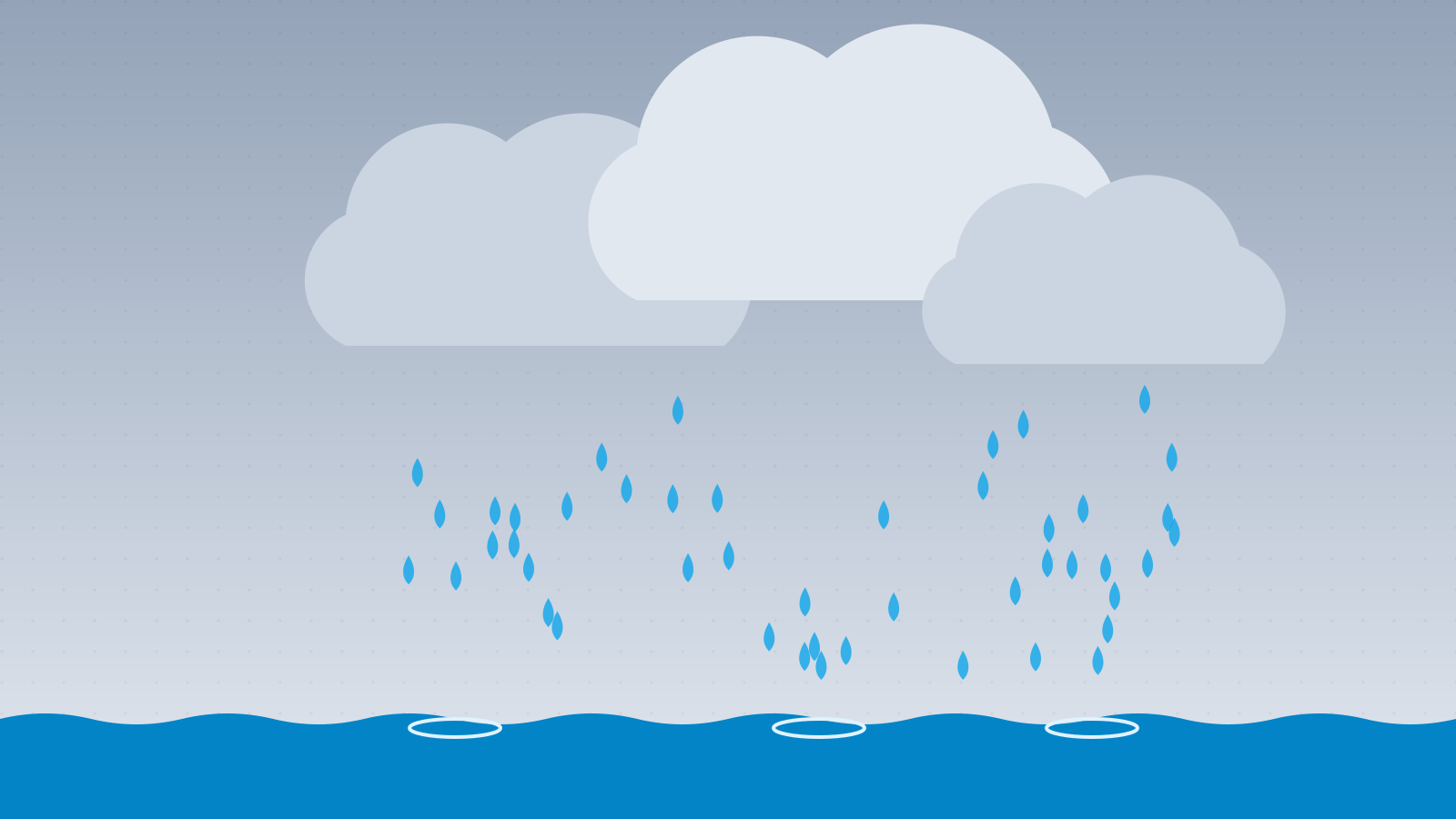
Moist air warmed by the Sun rises, expands and cools. When it cools to its dew point, its water vapour condenses onto tiny specks in the air — dust, salt and smoke — forming minuscule droplets. They are so small that they stay suspended, and together they make up a cloud. When droplets collide and merge, or ice crystals grow and then melt, they become heavy enough to fall as rain.
In this article (8)
Fluffy white clouds like cotton wool, a grey blanket across the horizon, then raindrops drumming on the window — clouds and rain are so ordinary that most of us barely notice them. Yet every raindrop is the end of a long journey taken by water evaporated from oceans, lakes and plants, kilometres up in the sky.
The water cycle: the planet’s giant pump
Water on Earth is constantly on the move:
- Evaporation: the Sun warms oceans, lakes and soil, and water evaporates into the air. Plants also release water vapour from their leaves.
- Condensation: as water vapour in the air cools, it turns back into liquid droplets, forming clouds.
- Precipitation: when droplets grow big enough, they fall as rain, snow or hail.
- Runoff: water returns to the cycle through rivers, groundwater and seas.
The energy driving this cycle comes entirely from the Sun. Clouds are the visible part of this vast system in the sky.
How does a cloud form?
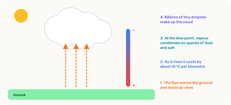
There is always some invisible water vapour in the air. For a cloud to form, that vapour must turn into liquid droplets — and for that, the air must cool.
1. Air rises
Air can rise in several ways:
- Heating: ground warmed by the Sun heats the air above it. Warm air is lighter and rises — this is how puffy summer-afternoon clouds are born.
- Mountains: when wind hits a mountain range, air is forced up the slopes. That is why the windward sides of mountains are so often wet.
- Weather fronts: when warm and cold air masses meet, the lighter warm air slides up over the cold air.
2. Rising air cools
The higher you go, the lower the air pressure. Rising air expands — and as it expands, it cools. Dry air cools by about 10 °C for every kilometre it rises, which is why mountain tops can be chilly even in midsummer.
3. Water vapour condenses
When air cools to a certain temperature, it can no longer hold all its water vapour. This temperature is the dew point, and at that point the vapour starts turning into liquid droplets.
But water vapour needs something to condense onto. That job is done by condensation nuclei floating in the air:
- tiny salt crystals left behind by sea spray;
- dust and pollen;
- smoke and other fine particles.
These specks are far too small to see, but without them clouds would form much less easily.
4. The cloud becomes visible
Each cloud droplet is only about 0.02 millimetres across, but a cloud contains billions of them. They scatter sunlight in all directions, making the cloud white and visible.
Why don’t clouds fall?
Clouds are surprisingly heavy. An average fluffy cloud can hold about 500 tonnes of water. So why doesn’t all that water fall on our heads?
The answer is the tiny size of the droplets. A cloud droplet is so small that air resistance almost stops it falling; droplets sink at just millimetres to about a centimetre per second. The rising currents that build clouds, meanwhile, blow upwards at several metres per second and easily hold the droplets aloft.
Those 500 tonnes of water are also spread through an enormous volume of air. The air inside a cloud weighs far more in total than the water it contains.
How is a raindrop made?
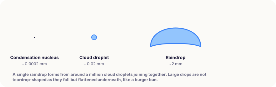
For a cloud droplet to fall to the ground as a raindrop, it must grow about a million times in volume.
That growth happens in two ways:
Collision and coalescence (in warm clouds)
In warm tropical clouds, droplets move at different speeds. Slightly larger ones fall faster, colliding with and swallowing smaller droplets. As a drop grows it falls faster, collides with more droplets and eventually becomes a raindrop.
Ice crystals (in cold clouds)
At mid-latitudes, including Europe, the upper parts of clouds are often below freezing. There, ice crystals coexist with liquid supercooled droplets. The ice crystals grow rapidly by drawing in water that evaporates from the droplets around them, until they become heavy enough to fall.
As they fall through warmer layers of air, the snowflakes melt into raindrops. So much of the rain that falls in Europe actually begins as snow high in the cloud. If the air is cold enough all the way down, the flakes reach the ground unmelted — and it snows.
The real shape of a raindrop
Raindrops are usually drawn as teardrops, but none of them actually look like that:
- Small drops (under about 1 millimetre) are almost perfectly spherical.
- Large drops flatten underneath as they fall because of air resistance, taking on the shape of a burger bun — round on top, flat below.
- Once a drop grows beyond about 4–5 millimetres, air resistance inflates it like a parachute and it eventually breaks into smaller drops.
How fast raindrops hit the ground depends on their size: fine drizzle falls at under 2 metres per second, while large drops can reach 9 metres per second.
Types of cloud
Clouds are classified by their shape and height:
| Cloud type | Appearance | What it means |
|---|---|---|
| Cumulus | Puffy, like cotton wool | Usually fair weather |
| Stratus | A flat grey layer | Overcast, drizzle |
| Cirrus | Thin, wispy, high up | Made of ice crystals; can herald a change in the weather |
| Cumulonimbus | Towering, with an anvil-shaped top | Downpours, storms, hail and lightning |
Cumulonimbus clouds can reach 10–15 kilometres high and are where lightning is born — see How does lightning form?.
The smell of rain
The pleasant earthy smell of the first rain after a dry spell has a name: petrichor. Its main source is geosmin, a substance produced by certain soil bacteria. The human nose is extraordinarily sensitive to geosmin and can detect it in tiny amounts.
High-speed camera studies have shown that raindrops hitting dry soil trap tiny air bubbles. As they burst, the bubbles fling microscopic particles carrying geosmin and plant oils into the air — and the wind carries the smell to us.
In short
Clouds form when moist air warmed by the Sun rises and cools. At its dew point, water vapour condenses onto specks of dust and salt, forming billions of tiny droplets — so small that rising air keeps them aloft. When droplets collide and merge, or ice crystals grow and melt on the way down, they become heavy enough to fall as rain. Every raindrop is a small but vital part of the water cycle that wraps our planet.
Frequently asked questions
If clouds are so heavy, why don’t they fall?
A cloud’s total weight is large, but each droplet is tiny and falls through the air extremely slowly. Rising air currents easily keep the droplets aloft. The water is also spread through a vast volume of air that weighs far more than the water itself.
Are raindrops really teardrop-shaped?
No. Small drops are spherical. Large drops flatten underneath as they fall because of air resistance, looking more like a burger bun. Once a drop exceeds 4–5 millimetres, it breaks apart into smaller drops.
Where does the smell of rain come from?
The first raindrops on dry ground release geosmin, a substance produced by soil bacteria, along with plant oils. That pleasant earthy smell is called petrichor.
Why are some clouds white and others grey?
Thin clouds scatter sunlight in all directions and look white. As a cloud thickens, most light is scattered and absorbed inside it and little reaches the base, which is why rain clouds look dark grey.
Sources
This article is based on peer-reviewed research and publications from trusted institutions, and it is reviewed regularly. How we work →
You might also wonder
All in Earth & Nature →
Why Do Leaves Change Colour in Autumn? The Science of Yellow, Orange and Red
Why do leaves turn yellow or red in autumn, and why do trees drop them? The pigments in leaves, colourful autumns and why America is redder than Europe.

How Do Rainbows Form? Light, Raindrops and the Secret of 42 Degrees
How do rainbows form, why are they curved and why do they appear opposite the Sun? Double rainbows, colour order and why you can never reach the end.
Why Is the Ocean Salty? Where Sea Salt Really Comes From
Why is seawater salty when rivers are fresh? How salt reaches the ocean from rocks and the seafloor, and why some seas are much saltier than others.
Why Is the Sky Blue? Rayleigh Scattering Explained Simply
Why is the sky blue and why are sunsets red? A clear explanation of how sunlight scatters in the atmosphere, and why we see blue instead of violet.

What Causes Tides? The Moon’s Invisible Pull on the Oceans
Why does the sea rise and fall twice a day? How the Moon and Sun create tides, why there are two high tides and why some coasts get huge tides and others none.
How Do Volcanoes Erupt? Magma, Gases and Why Some Explode
How do volcanoes form, and why do some ooze gentle lava while others explode violently? Follow magma’s journey from deep underground to the surface.